Hiking Thumb Butte in Prescott: Trail 33 Guide, Fees, and Tips
Fact-checked How we check
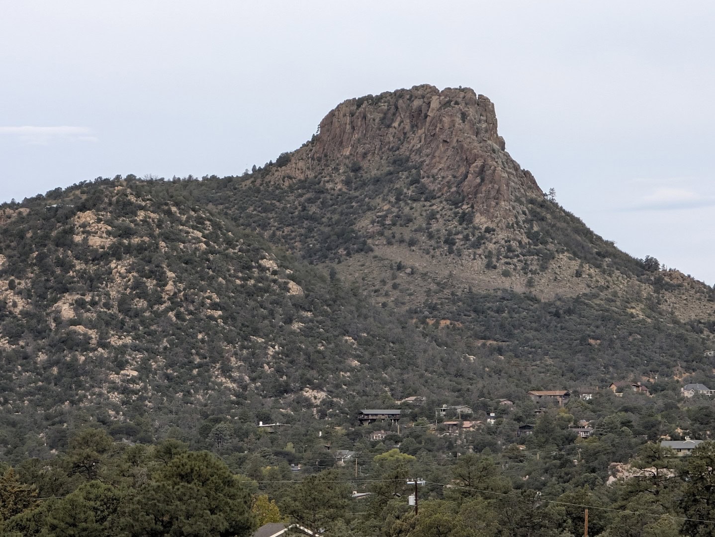
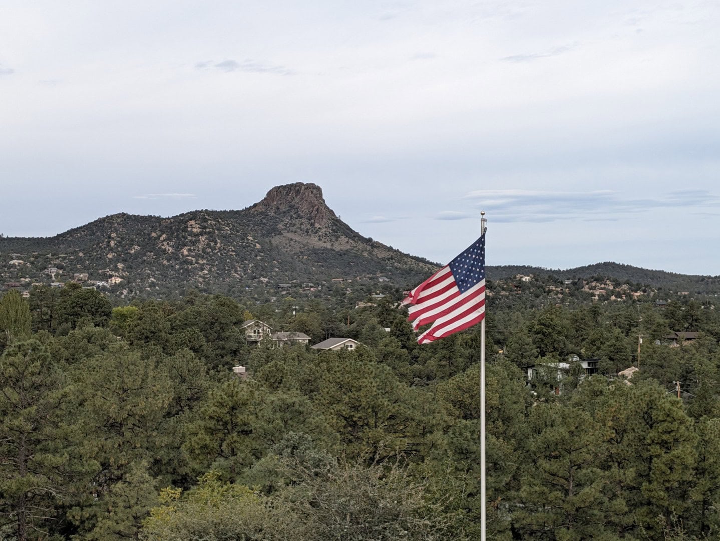
Every town has a landmark you can see from just about anywhere, and in Prescott it’s Thumb Butte. The rounded knob of rock rising out of the pines west of downtown shows up in the background of countless photos of the town, and, for a lot of locals, it was the first hike they ever took here. The good news is that you don’t have to be a climber to get up close. Thumb Butte Trail #33 is a short, steep, rewarding loop that starts a short drive from downtown and climbs to a saddle just below the summit, with views across Prescott to the Bradshaw Mountains, Granite Mountain, and Mingus. This is our local’s guide to hiking Thumb Butte: how to get there, which way to walk the loop, what it costs, when to go, and what you’re looking at once you reach the top.
| Where | Thumb Butte Recreation Area, about 3½ miles west of the Courthouse Plaza on Thumb Butte Road (Gurley Street becomes Thumb Butte Road) |
| Main trail | Thumb Butte Trail #33, a loop of roughly 2 miles with about 600 feet of climbing |
| Difficulty | Easy to moderate distance, but steep in places; allow about an hour |
| Fee | $5 per vehicle per day (free on Wednesdays); Prescott National Forest and America the Beautiful passes accepted |
| Day-use hours | Oct 1 – end of Feb: 7 a.m.–5 p.m. · Mar–Apr: 7 a.m.–7 p.m. · May–Sept: 6 a.m.–8 p.m. |
| Dogs | Yes, on a leash |
| Bikes and horses | Not on Trail #33; bikes and horses use the surrounding trail network |
| Best time | Spring and fall; early mornings in summer; traction spikes in icy winter weather |
Why Thumb Butte is Prescott’s signature hike
Prescott has bigger hikes, longer hikes, and lonelier hikes, but none of them are as woven into the town as this one. Thumb Butte is close enough to downtown that you can be on the trail fifteen minutes after finishing breakfast on the plaza, short enough to fit into a lunch break, and steep enough to feel like you earned the view. It’s also one of the most heavily used trails in the entire Prescott National Forest, which tells you something: this is where locals take visiting relatives, where people train for bigger climbs, and where plenty of residents walk a few times a week simply because it’s there. Along the way you’ll find benches for catching your breath and interpretive signs about the plants, wildlife, and history of the area, so it works as a nature walk as much as a workout.
The butte itself is the main event. Seen from town it looks a little like a thumb raised over the forest, which is where the name comes from. Early Anglo settlers also called it “the Sphinx,” and according to the Sharlot Hall Museum, the Yavapai name for it describes a mountain lion lying down. Once you’re on the trail and see the rock up close, all three names make sense depending on where you’re standing.
Getting to the trailhead
From downtown, head west on Gurley Street past the Sharlot Hall Museum and keep going. As you leave the neighborhoods behind, Gurley turns into Thumb Butte Road and starts climbing into the pines. The Thumb Butte Recreation Area parking lot is on the right side of the road, roughly 3½ miles from the plaza, and the whole drive is paved. Trail #33 starts on the opposite (south) side of the road, so cross carefully at the crosswalk. Beyond the recreation area, Thumb Butte Road turns to dirt and continues into the forest, which is the start of a longer backroads drive we’ll mention below.
The parking area has a fee station, picnic tables, and seasonal water and restrooms. On a nice weekend morning the lot gets busy, so arriving early makes life easier. There’s also a reservable group picnic area with a covered pavilion, grills, and room for large gatherings, which is booked through Recreation.gov and is a popular spot for family reunions and company picnics.
Fees, passes, and hours
Thumb Butte is a Forest Service fee site. Day use is $5 per vehicle, paid at the pay station in the lot, and that day pass also covers other standard-amenity fee sites on the Prescott National Forest the same day, so you can hike Thumb Butte in the morning and picnic at Lynx Lake in the afternoon on one receipt. Wednesdays are free. If you hike around Prescott often, the Prescott National Forest annual pass ($40) pays for itself quickly, and federal America the Beautiful passes are accepted too.
Pay attention to the day-use hours, which change with the seasons. From October 1 through the end of February the area is open 7 a.m. to 5 p.m.; in March and April it’s 7 a.m. to 7 p.m.; and from May through September it’s 6 a.m. to 8 p.m. That winter 5 p.m. close catches people out: if you’re hoping to catch sunset from the saddle in December, the gate math doesn’t work, so plan a mid-afternoon hike instead.
Insider Tip: Wednesday is the free day, and a weekday morning is also when the trail is at its quietest. If you can swing a midweek hike, you get the lot, the benches, and the view mostly to yourself, and it costs nothing.
Hiking the Thumb Butte loop, step by step
Trail #33 is a loop of roughly two miles (sources put it anywhere from about 1.75 to 2.1 miles depending on how they measure the spur at the top) with around 600 feet of elevation gain. It starts near 5,700 feet and tops out at a saddle a little above 6,300 feet, just below the rock of the butte itself. Most people finish in about an hour, longer if you linger at the overlook, which you should.
Shortly after leaving the trailhead, the trail splits. This fork is the one decision you need to make:
- The left fork (east side) is paved and steep, with tight switchbacks climbing straight up toward the saddle. The Forest Service paved this side to control erosion on what had become a very heavily used climb. It’s a genuine leg-burner, with some pitches far steeper than the trail’s average grade.
- The right fork (west side) is a dirt trail with a gentler, more gradual climb through the pines and chaparral, with the interpretive stops spaced along the way.
Many hikers take the right fork up the gentler dirt side and come down the paved side. That gives you the easier climb and a quick, if knee-testing, descent. Plenty of locals do the reverse on purpose for a harder workout, charging up the pavement and cruising down the dirt. Either way works; just know that the paved switchbacks are steep enough to feel on the way down, so take your time, especially with kids or if the pavement is wet or icy.
Near the high point, a short spur leads out to an overlook above Prescott. Don’t skip it. This is the payoff view: the whole town spread out below you, the courthouse dome among the trees, and the mountains rolling away in every direction. There’s no hiking trail to the actual summit of the butte; the top is a technical rock climb, and the trail stays below the rock. Once you’ve soaked in the view, continue around the loop and back down to the road.
Insider Tip: Remember the altitude. You’re starting near 5,700 feet and climbing 600 more in about a mile of uphill. Visitors from sea level (and even from Phoenix) feel it on the steep sections, so carry more water than you think you need and take advantage of the benches.
What you’ll see from the top
On a clear day, the overlook near the top of the loop is one of the best free views in Prescott. Below you is the town itself, with downtown and the plaza tucked into the trees. To the south and east rise the Bradshaw Mountains, the range that holds Mount Union and the Groom Creek area. To the north you can pick out Granite Mountain, the big bald granite dome of the Granite Mountain Wilderness, and the Sierra Prieta ridge to the west. To the east, Mingus Mountain marks the high country above Jerome. On the clearest days, especially after a storm has scrubbed the air, the San Francisco Peaks above Flagstaff show up far to the north, often with snow on them from fall through spring.
The best light is in the morning, when the sun is behind you looking out over town, and in the late afternoon from spring through early fall, when the low sun turns the rock of the butte gold. Just keep the gate hours in mind if you’re chasing that late light.
The rock itself: geology and the falcons
Thumb Butte looks like it might be granite, like so much of the rock around Prescott, but it isn’t. It’s a knob of volcanic rock, often described as a volcanic plug, that geologists date to roughly 15 million years ago, sitting on top of the far older granitic rock that makes up much of the area. The hard volcanic rock resisted erosion while the land around it wore away, leaving the butte standing well above the surrounding hills and roughly 1,200 feet above downtown.
Those cliffs are home to some famous residents. Peregrine falcons have nested on Thumb Butte for well over two decades, and the Forest Service protects them with an annual closure from February 1 through July 15. During that window the climbing routes, the summit, and the base areas of the cliffs are closed to protect the nesting birds. Trail #33 stays open during the closure, so the closure doesn’t affect hikers on the loop, and if you’re lucky you may spot a falcon hunting over the forest. Rock climbers should check the current Prescott National Forest climbing information before heading up, since the closure dates and any extensions are announced each year.
Get the Insider in your inbox
Local events, new places, and weekend ideas in one friendly email.
Plants and wildlife along the trail
The Thumb Butte area sits right where Prescott’s forest types meet. You’ll walk through tall ponderosa pines mixed with piñon pine and the checkered bark of alligator juniper, with chaparral on the sunnier slopes: red-barked manzanita, scrub oak, yucca, and the occasional cactus. The interpretive signs along the loop point out many of them, which makes this a good hike for kids who like to identify things.
Deer are common, especially early and late in the day, and the area is also home to coyotes, foxes, bobcats, and mountain lions, though the cats are rarely seen. In warm months you may also share the trail with snakes, including rattlesnakes; a sign at the trailhead reminds hikers to watch where they step. Keep dogs leashed (it’s required) and close, give any snake plenty of room, and it will happily go about its business. Birders should watch the sky and the cliffs for the falcons and other raptors.
Thumb Butte through the seasons
Spring is prime time: cool, sunny, green, and before the summer heat. Summer is still very hikeable thanks to the elevation, but go early. From roughly July into September the monsoon brings afternoon thunderstorms, and an exposed saddle is no place to be when lightning starts, so plan to be down by early afternoon and turn around if clouds build. Fall brings crisp mornings, clear air for long views, and some seasonal color as the scrub oaks turn rusty gold, typically in the second half of October; check our Prescott Fall Color Report for where things stand around town. Winter can be lovely on sunny days, but the shaded switchbacks hold ice after storms, and the paved section can be slick. Microspikes or other traction devices make a big difference, and if it’s truly icy, save the hike for another day.
Hiking with kids and dogs
Thumb Butte is a great first “real” hike for kids. It’s short, there’s a clear goal (the overlook), the benches give natural rest stops, and the signs give them something to read along the way. The steep paved section is the hardest part, so going up the dirt side and down the pavement is usually easier on little legs on the way up. Hold hands on the way down the switchbacks, and keep kids on the trail near the overlook. For an even gentler option, the short Miller Creek Trail nearby is a mellow family walk.
Dogs are welcome on a leash, and they love it, but bring water for them too: there’s no reliable water on the trail, and the pavement gets hot on summer afternoons. Pack out anything your dog leaves behind; with this many visitors, it adds up fast.
More trails from the Thumb Butte area
The loop is just the beginning. The Thumb Butte area is a hub for a whole web of Forest Service trails, which is handy if you want to stretch your legs further, ride a bike, or find a quieter path:
- Thumb Butte Spur #314 connects the loop to the wider network.
- Thumb Butte Bypass #326 parallels Miller Creek; it’s open to hikers, bikes, and horses.
- Miller Creek #367 is a short, easy trail that works well for families.
- The Prescott Circle Trail, a loop of roughly 50 miles around the city, passes through the area, so you can hike a segment of it from here.
- The north-side trails climb to viewpoints with long looks north toward the San Francisco Peaks. Horse riders use the west trailhead on Forest Road 9401B, since there’s no horse-trailer parking at the main lot.
Forest Service trail maps for the north and south Thumb Butte networks are available from the Bradshaw Ranger District, and our Prescott Trail Finder lets you filter local hikes by distance, difficulty, shade, and whether dogs are allowed. If Thumb Butte has you hooked, our guide to beginner hikes in Prescott is a good next step.
Make a day of it
Because Thumb Butte is so close to town, it pairs easily with everything else Prescott does well. Hike early, then head back down Gurley Street for breakfast or coffee downtown; our guides to the best breakfast in Prescott and the best coffee shops have you covered. On the way, stop at the Sharlot Hall Museum on Gurley to learn about the territorial town you just looked down on, or read up first in our history of Prescott.
If you have a high-clearance vehicle and some time, the dirt continuation of Thumb Butte Road is the start of a scenic backroads loop through the national forest that eventually connects to Copper Basin Road. It’s a slow, bumpy, beautiful drive through the pines; check road conditions first, and skip it in a low-clearance car or after heavy rain. For a gentler afternoon, the lakes are close by: our guide to Prescott’s lakes covers Lynx, Goldwater, Watson, and Willow, and your Thumb Butte day pass covers other standard Forest Service fee sites that same day.
Insider Tip: Keep your Thumb Butte receipt on the dashboard. The $5 day pass is good at other standard-amenity fee sites on the Prescott National Forest that same day, so a morning hike and an afternoon at the lake cost the same as one stop.
Know before you go
- Bring water and sun protection. Even on cool days the Arizona sun is strong at this elevation, and there’s no water on the trail.
- Wear real shoes. The dirt side is rocky in spots, and the paved side is steep enough that grippy soles matter on the way down.
- Watch the weather. Afternoon monsoon storms in summer and ice in winter are the two big hazards.
- Stay on the trail. Shortcutting switchbacks causes erosion on a trail that sees thousands of visitors a month.
- Check current conditions. The Prescott National Forest’s Bradshaw Ranger District (344 S. Cortez St., 928-443-8000) has the latest on closures, fees, and trail conditions.
- Leave the rock to climbers. The summit is technical, and the cliffs are closed every year from February 1 to July 15 for nesting falcons.
Thumb Butte is the kind of hike that never really gets old. It’s short enough to do on a whim, steep enough to count as exercise, and the view from the top still stops you in your tracks no matter how many times you’ve seen it. Whether you’re visiting for a weekend or you’ve lived here for years, it’s the hike that makes Prescott feel like Prescott. For more ideas once you’re back down, see our roundup of outdoor things to do in Prescott, and if you’re planning a trip, our guide to visiting Prescott covers where to stay and how to make the most of your time here.
Something changed? Let us know
Enjoyed this? Get more Prescott in your inbox
Weekend picks, new places, and local events from people who love Prescott. Free, and you can unsubscribe anytime.